Roaring Fork Valley faces dismally dry January
Warm, dry winter beginning to cast shadow over summer 2026

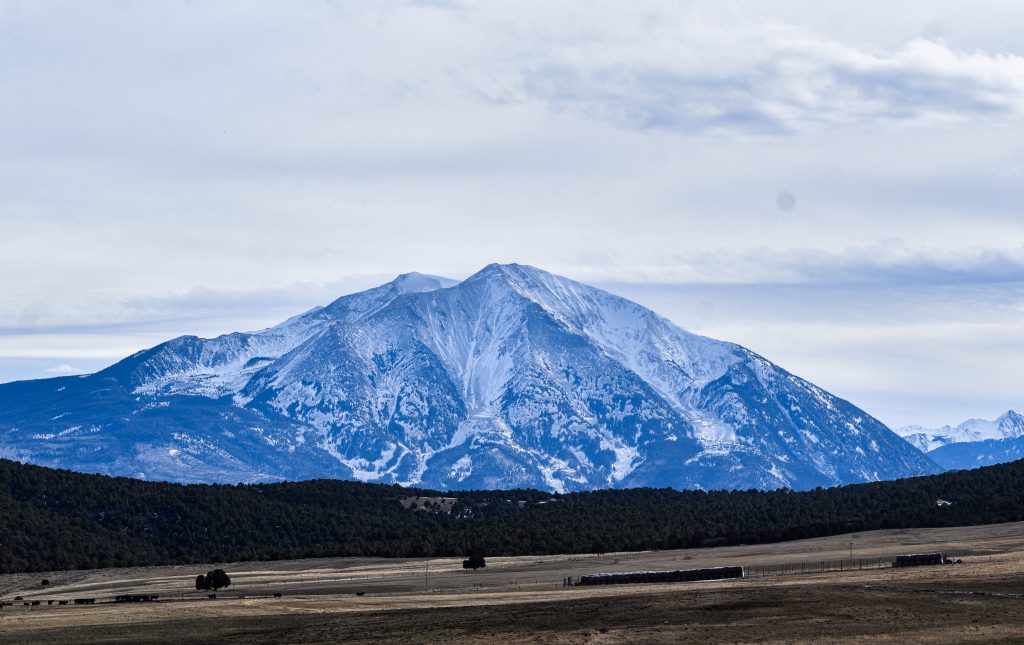
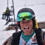
Jaymin Kanzer/Post Independent
It doesn’t matter if you’re a full-time ski bum, a longtime resident, or a first time visitor — the ramifications of the distressing 2025-26 winter on the Western Slope impacts everyone.
The combination of unseasonably warm temperatures and jarring lack of snow has created a perfect storm — or lack thereof — and will continue to impact agriculture, recreation, and potable water for over 30 million people long after the 2025-26 winter concludes.
Warm reality
Brendon Langenhuizen, the Director of Technical Advocacy for the Colorado River Water Conservation District, compared the snowpack to a reservoir but said the extreme heat is detracting from the benefits of a natural reserve.
“How warm it’s been has been a concern for me, because snowpack is really a big reservoir for us,” he said. “You can hold that water for the warmer times of the year and then it slowly runs off or melts into the deltas and then comes back into the rivers later in the summer when we need it for crops and water temperatures and recreation.
“If we have these really warm temps continuing, it just diminishes the snowpack and we can’t hold as much snow into the spring — making it so even if we had the moisture, we wouldn’t be able to hold it.”
According to a Colorado Climate Center graph, parts of Colorado experienced some temperatures exceeding averages by double digits during the first week of January. The graph shows all of Garfield County experienced average temperatures at least eight degrees hotter than average, with northern Garfield County facing average temperatures at least 12 degrees hotter than average.
He continued to explain that there was already evidence of a fast runoff, using the Dotsero marker on the Colorado River as reference.
“In November, our flows were really low, around the fifth percentile,” he said. “Typically flows would be reduced, but our flows have actually been increasing, and so our flows are currently in the 22nd percentile.”
Erin Walter, a Service Hydrologist at the Grand Junction National Weather Service, noted that although the Climate Prediction Center’s precipitation outlook doesn’t yet project a majority of Colorado to not reach the median, other sources aren’t as optimistic.
“For example, the University of Arizona has some seasonal temperature, precipitation and snowpack forecasts — for January through March, they have a forecast of below normal and their forecasts extend much further north, including northwest Colorado,” she said.
“It’s essentially saying that there’s below normal snowpack favored over most of the West for the remainder of the season,” she continued. “That’s based on what was seen in historical seasons and the statistics we’re at right now. It’s not the end-all-be-all, but I would say that it’s becoming more difficult to reach our normal precipitation for the winter season.”
Although the area has finally experienced some precipitation since the calendar flipped to 2026, the temperatures aren’t letting a solid base build in the higher alpines – further threatening the snowpack. Walter admitted that every little bit helps, but doesn’t think the recent storms were enough to move the needle, especially since the forecast dries out after Thursday night.
“Any little bit will help, but whether that’ll change and flip-flop where we are with our current snowpack? I don’t think so, because we are pretty behind for most of our mountain ranges,” Walter said.
Langenhuizen held a little more optimism, saying it’s still early in the season and much could change before Punxsutawney Phil sees his shadow.
“Our snowpack is really similar to that of 2018, but it could go in so many different directions,” Langenhuizen said. “In 2018, we kind of extended our season because it was a little colder and wetter after April.
“But in 2012, we were at around the same spot, and we didn’t get any moisture and it really warmed up and we ended up setting records for how dry it was in 2012. There’s also another instance in 2000, where we almost got to the median. Really anything can happen, it’s still early in the year.”
The lack of snow is causing immediate recreational consequences in the Roaring Fork Valley as well as setting up the area for what could be a concerning fire season. Walter and Langenhuizen both compared the current winter to that of 2018 — a year many associate with the Lake Christine Fire in Basalt, which burned over 12,500 acres and caused over $25 million in damage throughout 13 weeks — but also caveated by saying a wet spring could mitigate the risk.
“Naturally, having less of that moisture stored in our higher terrain and drier soils, that certainly starts us off more susceptible to fire danger and worsening drought conditions,” Walter said. “That will greatly depend on how our spring evolves. If we have a warm and dry spring, we could see that runoff rather quickly, but if it’s a colder and a seasonably wet spring, that could support us. It’s certainly not helping the conditions if we end the year with below normal snowpack.”
“Our median snowpack is about 17 inches of water,” Langenhuizen continued. “Right now, we’re essentially at 4.4 — typically we’d be around 7.5. We’re about half of what we should be, but we’re at the beginning part of the season. It could still turn into a pretty decent year, but we’re certainly not starting off strong.”
Recreation
The Roaring Fork Valley cultivates hidden gems of the Colorado Rockies, one of the driving factors for the area featuring such a lively community — a community that’s facing a dearth of winter recreation possibilities due to warm temperatures and lack of snow.
After the largest investment in Sunlight Mountain Resort history, the local mountain has had to hold off on opening much of their terrain due to challenging conditions, although following the recent storms, the mountain announced the new Primo lift and more terrain will open on Friday, Jan. 9 during Skier Appreciation Day.
The nearby Spring Gulch Nordic Trail System — featuring over 28 kilometers of groomed cross-country ski trails — has only been able to open around 5 kilometers to Rachel Bachman Perkins, executive director of the Mount Sopris Nordic Council.
She explained that their best skiing right now is a sheltered area above 8,000 feet, a 2-kilometer trail named Finlandia.
“We’ve been doing whatever we can to preserve and provide access to that trail, but we haven’t really had a lot of other trails that have been skiable for significant stretches,” Perkins said. “There’s no snowmaking capacity up there, so we’re completely at the whims of the weather.”
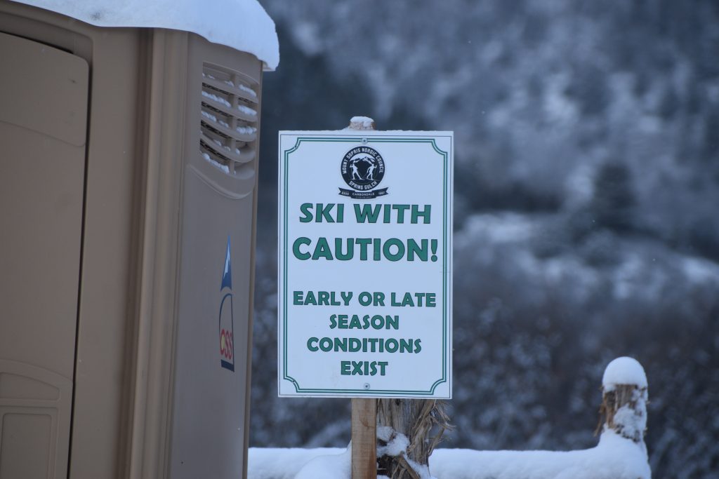
The nonprofit Mount Sopris Nordic Council has invested heavily into creating more climate-resilient terrain and snow farming capacities to help bring snow to areas that could actually be skied upon. Perkins said the only terrain open at the moment has been built within the past three years.
A Thursday morning update from the Mount Sopris Nordic Club goes into more detail about the conditions.
Although Spring Gulch isn’t seeing nearly the same snow volume as it normally does, Perkins said the attitude of the community remains strong.
“Everyone understands the reality, and I think their expectations of what the skiing is going to be like are pretty low, maybe even the fact that we have snow at all exceeds expectations,” she said. “When you get out there and it’s a blue sky day, you get to enjoy Sopris and the view, people are overall incredibly positive. Hearing things like ‘We’re grateful to be able to come out and ski, even if it’s bony and thin,’ is really motivating for us.
“Seeing how accepting and grateful people have been about the access that we’re able to provide in light of the circumstances is very encouraging,” she continued. “I think people are worried about the future, and the summer and all kinds of things, but in terms of what we’ve been able to provide, I’ve been surprised and encouraged by how positive the feedback has been.”
On the other hand, Red Hill is facing a different challenge: damaging use during wet conditions. According to the Bureau of Land Management, the hike that features Mushroom Rock sees over 70,000 visitors every year.
“Red Hill is unique in that the entrance is south facing, so when you look at it from a distance it looks sunny and warm and dry, but the trail network doesn’t remain in those areas,” Red Hill Council President Chris Brandt said. “Within the first quarter mile, there are areas that are north facing and shaded and colder. That’s where we’re seeing muddy surface conditions.
The area is managed by the Red Hill Council, a nonprofit made up of local volunteers dedicated to preserving the 19 miles of trails, a task becoming increasingly more difficult as “sminter” continues. The Red Hill Council partners with the Roaring Fork Outdoor Volunteers to do maintenance work on the trail system every year, but Brandt said that ongoing use during the warmer winter is undoing all of the hard work by those volunteers.
“We’re seeing tremendous resource damage,” he continued. “We’re seeing tremendous soil loss, soil erosion, we’re seeing people bypassing the mud by widening the trail, but by doing that they’re compacting the sensitive biocrust soils and trampling vegetation. There’s a pretty severe impact corridor along all the routes from this high volume use, so we’re trying to encourage people to be more respectful and careful when they choose to visit.”
He continued to explain the council has monikered the phrase “If you’re leaving a muddy track, turn back” to emphasize the state the trail should be in as well as the fact that it’s a public resource used by tens of thousands every year. By using a muddy trail during the winter, the mud will harden overnight and leave the trail misshapen, a problem further highlighted when hundreds use the trail every day.
“The simple thing is if you’re walking on the trail and it’s so soft and squishy that you’re leaving imprinted footprints and squishing divots into the trails, that’s too soft to visit,” Brandt said. “But if it’s snowpacked or firm and frozen, those are perfectly good times to go. We’re just giving them rationale for the time when they make their own decision and choose whether or not they want to damage the resource or protect it through their actions.”
The trail system is split into three zones, to which the council is trying to turn into an opportunity for hikers to communicate with each other. The Red Hill Trailhead now features a “Muddy Meter” that features all three zones and three sliding arrows to signify the conditions of each zone.
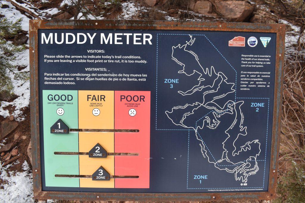
“We actually ask our users to communicate to others via the sliding arrow marker, so you can actually communicate to others what you’ve seen,” Brandt said. “If it’s muddy, we slide it to the red, which is poor conditions, and that’s a way to alert other users that that particular route isn’t a wise place to go.”
Brandt concluded by explaining this isn’t the first year the Council has had to face this challenge, but said if the pattern continues “different management policies might need to be implemented.”
“We’ve been fighting this for years — there’s been regular and severe damage,” he said. “Red Hill sees the most use during the months when it’s most sensitive to damage. Our highest visitation is when people are sort of desperate for winter to be over and they’re seeking a spring activity.
“The ultimate outcome if our users aren’t able to change their ways is that different management policies might need to be implemented. That could result in seasonal closures, it could result in permits or fees or licenses or rangers monitoring. It’s a whole different animal, so we’re really trying to urge people to be a little more respectful when they choose to use this resource.”


Support Local Journalism
Support Local Journalism
Readers around Glenwood Springs and Garfield County make the Post Independent’s work possible. Your financial contribution supports our efforts to deliver quality, locally relevant journalism.
Now more than ever, your support is critical to help us keep our community informed about the evolving coronavirus pandemic and the impact it is having locally. Every contribution, however large or small, will make a difference.
Each donation will be used exclusively for the development and creation of increased news coverage.