Meteorologists see 3 snowstorms ahead of Thanksgiving, will it be enough to reverse Colorado’s dry start to the season?
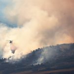
Arapahoe Basin Ski Area, Breckenridge Ski Resort, Loveland Ski Area, Keystone Resort, Copper Mountain and Winter Park Resort have all opened for the season, relying on machine-made snow


Post Independent File photo
Colorado’s unusually dry fall could be coming to an end, as forecasters predict a wave of snowstorms to start this weekend and continue until about Thanksgiving.
Meteorologist Seth Linden — who runs Seth’s Weather Report, a popular Facebook page that provides mountain forecasts — said that the incoming snow will be welcomed by the state’s mountain towns, where the local economies rely on snow to drive tourism.
“Summit County, Eagle County, Grand County, the Central Rockies — communities depend on good snow for advertising,” Linden said. “It draws people in. Good snow, a good base and a good snow pack brings people in. That’s the opposite of what it is right now.”
Colorado’s snowpack as of Wednesday was at 19% of median for this time of year. That ranks in the 5th percentile, meaning 95% of years on record have had a deeper snowpack at this point in the season.
So far, Arapahoe Basin Ski Area, Breckenridge Ski Resort, Loveland Ski Area, Keystone Resort, Copper Mountain and Winter Park Resort have opened, relying almost entirely on machine-made snow.
While it is hard to say exactly how much snow this series of storms will bring to Colorado, Linden said the series of storms should help boost local economies, hype up skiers and snowboarders and help ski areas open more terrain ahead of the Thanksgiving holiday.
“It does appear we are going to enter a much more active period for the West,” he said. “Previously, there had been this big area of low pressure on the east coast and this big area of high pressure over the West. That’s going to flip-flop this weekend.”
The first storm is expected to hit Colorado on Sunday and Monday, favoring the southern mountains, including the San Juan Mountains. Linden said ski areas such as Silverton Mountain and Wolf Creek, neither of which have opened yet, could see 6-12 inches of snow accumulation or more. While the northern mountains are expected to see less snow, he said ski areas in the central and northern mountains could see 1-5 inches of fresh snow.
Following that storm, models are showing the potential for another snowstorm from about Tuesday, Nov. 18, to Wednesday, Nov. 19, Linden said. That storm is again expected to favor the southern mountains. Right now, he said, the second storm “appears relatively minor.”
Finally, between Thursday, Nov. 20, and Saturday, Nov. 22, Linden said a “bigger, colder system” may move into the mountains, although it is too far out to say with much certainty how much snow that storm could bring. He said this third storm is looking like it will favor Colorado’s northern mountains and ski areas along the Interstate 70 corridor.
“That one I’m eyeing with much colder air and a much stronger shot of snowfall for the mountains,” Linden said. “So, I do think when we get to the weekend before Thanksgiving, there should be some snow on the ground.”
OpenSnow Founding Meteorologist Joel Gratz wrote in a blog post Wednesday that this year’s dry start to the season is similar to three other seasons in Colorado — 1999-2000, 2001-02 and 2016-17 — when there was little to no snow through about Nov. 10.
Despite the slow start, the 1999-2000 and 2016-17 seasons wound up with an about-average snowpack at the end of the season, Gratz said. During the 2001-02 season, however, the snowpack remained at a record low through much of the winter.
Whether or not these three upcoming storms deliver as expected, Gratz noted temperatures are forecasted to drop starting Monday, allowing ski resorts to turn on the snow guns for longer periods of time.
“Snowmaking conditions should become more favorable as colder air moves into the Rockies, and there could be times of 24/7 snowmaking,” Gratz said. “So we have that going for us.”
Though the season has started out with little snow, Linden said this season’s La Niña pattern could still result in enough snow for good skiing in Colorado’s central and northern mountains, as it has historically. He said he’s less certain on how the La Niña pattern may play out in the southern mountains.
La Niña is a climate pattern of cooler-than-average surface temperatures off the Pacific Coast, typically resulting in warmer temperatures in the southern U.S. and colder temperatures in the north, according to the National Oceanic and Atmospheric Administration.
“The La Niña is going to persist and then probably transition to neutral or El Niño,” Linden said. “That will typically drive good flow for Colorado’s north-central mountains, like I-70 ski areas. I think it could still be a good season.”


Support Local Journalism
Support Local Journalism
Readers around Glenwood Springs and Garfield County make the Post Independent’s work possible. Your financial contribution supports our efforts to deliver quality, locally relevant journalism.
Now more than ever, your support is critical to help us keep our community informed about the evolving coronavirus pandemic and the impact it is having locally. Every contribution, however large or small, will make a difference.
Each donation will be used exclusively for the development and creation of increased news coverage.