Hanging Lake source water study highlights complex nature of canyon’s cave geology


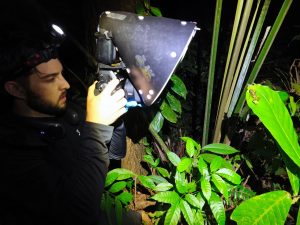
White River National Forest/Courtesy photo
The shortest distance between the headwaters above the north rim of Glenwood Canyon and the canyon’s most iconic feature, Hanging Lake, is anything but a straight line.
Along the way, a portion of that water takes a detour underground through the canyon’s expansive karst system before making its way back to the surface.
How much of that groundwater ends up in Hanging Lake, and from where, versus how much flows into the lake directly from the surface are still questions to be answered, water scientist David Woods said.
“It has been theorized that the water in Hanging Lake has been in the ground for a very long time, but what we’re seeing is that at least some of it has not been in the ground long before it enters the lake,” said Woods, who is leading a project to try to pinpoint Hanging Lake’s water sources.
Woods and his team of researchers from Ozark Underground Laboratories, which specializes in tracing water sources, have released their initial findings in the study that began last fall following the devastating mud and debris flows in the canyon, which resulted from heavy rains over the 2020 Grizzly Creek burn scar.
“The Grizzly Creek Fire highlighted the need for the Forest to better understand the hydrology of the area to help protect the source water for Hanging Lake,” said Leanne Veldhuis, Eagle-Holy Cross District ranger, in a release announcing the source water study progress report.
Researchers began a dye-tracing investigation last fall, establishing 11 dye-tracing stations at Hanging Lake and surrounding areas. Unique tracer dyes were then placed in three areas above Hanging Lake — the East and West forks of Deadhorse Creek, as well as the adjacent, but physically separate, French Creek drainage.
This spring, tracer dye introduced into the West Fork of Deadhorse Creek was detected in Hanging Lake, even though there is no surface connection between the two, Woods said.
Because the confluence between the West Fork and East Fork of Deadhorse Creek is below Hanging Lake, that finding establishes a groundwater connection between West Fork and the springs that supply water to Hanging Lake, he explained.
Surface water does enter Hanging Lake from the East Fork of Deadhorse Creek, where the nearby Bridal Veil Falls is located. However, dye introduced into that drainage was not detected in Hanging Lake or any of the sampling stations downstream in Deadhorse Creek, Woods said.
That may have been a result of the time of year, late in the summer season, when the initial dye research was conducted, he said.
Interestingly, the study also established a groundwater connection from the East Fork of Deadhorse Creek to the neighboring French Creek drainage. That’s solely the result of groundwater flow between the two basins, Woods said.
“These preliminary results highlight the complexity of the cave and karst geology of this area, which contributes to Hanging Lake’s special features,” Woods said.
The study is being funded through the National Forest Foundation, and is meant to help the Forest Service employ measures to better protect Hanging Lake and other parts of the canyon during future wildfire and debris flow events, Veldhuis said.
Woods and his team plan to return to the area in early August to expand the research sites into additional areas that could also contribute to the Hanging Lake source water.
Among the things they hope to determine is the travel time for underground water from the West Fork drainage to Hanging Lake.
The straight-line distance between the West Fork dye introduction site and Hanging Lake is approximately 5.5 miles, with an approximate elevation change of 2,520 feet, Woods said.
By understanding the travel time for groundwater to reach the lake, researchers can then get a better sense of just how much water that comes into Hanging Lake is from underground and how much is from surface flow.
That can then help forest managers know better how to deal with wildfire and firefighting tactics, as well as mitigation for flood events, in order to protect Hanging Lake.
Placing dye tracers and samples in the water earlier in the summer should also result in research data this fall before the snow falls and streams freeze, Woods said.
Although the mud flows last summer did not severely impact the lake itself, at least not in the short term, the trail leading to the lake was heavily damaged.
A temporary trail providing access to the lake on a permit basis was only just reopened June 25 after a near yearlong closure of the area.
The water source research team’s progress report can be found at http://www.fs.usda.gov/whiteriver.
Senior Reporter/Managing Editor John Stroud can be reached at 970-384-9160 or jstroud@postindependent.com.

Support Local Journalism
Support Local Journalism
Readers around Glenwood Springs and Garfield County make the Post Independent’s work possible. Your financial contribution supports our efforts to deliver quality, locally relevant journalism.
Now more than ever, your support is critical to help us keep our community informed about the evolving coronavirus pandemic and the impact it is having locally. Every contribution, however large or small, will make a difference.
Each donation will be used exclusively for the development and creation of increased news coverage.