Thursday update: Southern push grows Lee Fire to 127,000 acres; evacuations remain in place

Trevor Ballantyne/Steamboat Pilot & Today
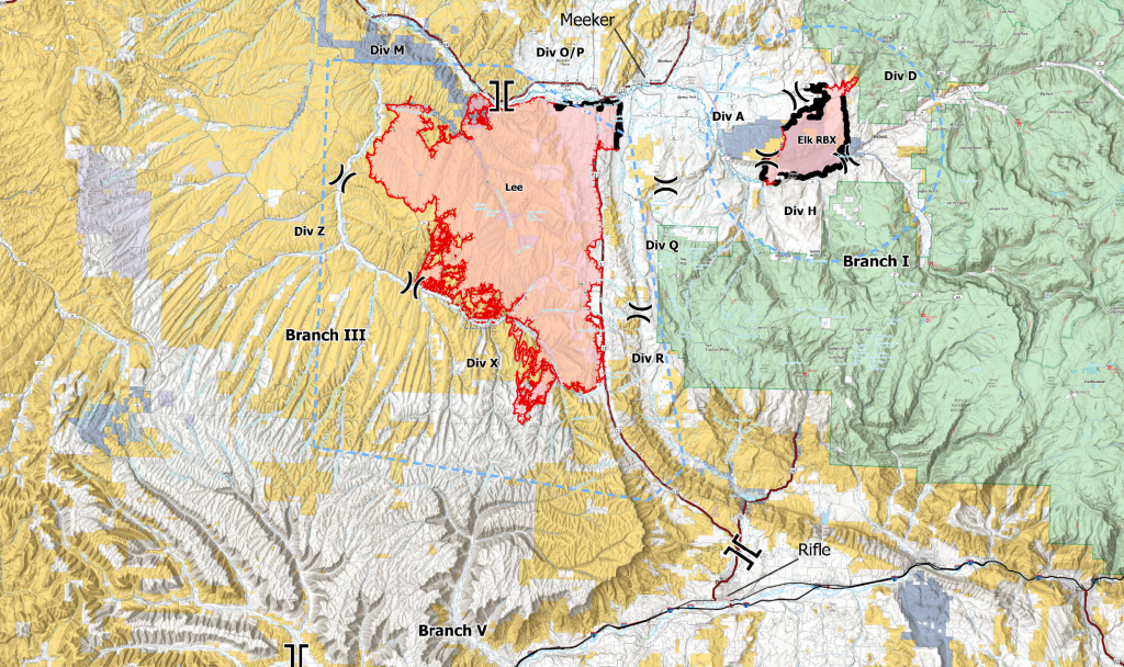
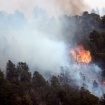
The Lee Fire grew to 127,107 acres Thursday morning, an increase of nearly 6,500 acres since Wednesday, as hot, dry and windy conditions persisted in the southern portion of the blaze. Containment dropped to 3% Thursday, down from 4% on Wednesday and 6% on Tuesday, but fire officials said the decrease was due to the fire’s expanding perimeter and not the loss of existing containment lines.
The Elk Fire decreased slightly in reported acreage to 14,518 acres due to more accurate mapping and remains 75% contained. Both fires were sparked by lightning on Aug. 2 and are being fought by 1,274 personnel using 10 aircraft, 20 hand crews, 81 engines and 35 pieces of heavy equipment.
Critical fire weather continued Thursday, with improvement expected Friday. Forecasters anticipated winds shifting to the west and southwest with gusts over 20 mph, afternoon highs in the upper 80s to mid-90s, relative humidity between 8–12% and the possibility of dry thunderstorms producing erratic winds, according to the Rocky Mountain Area Complex Incident Management Team 3.
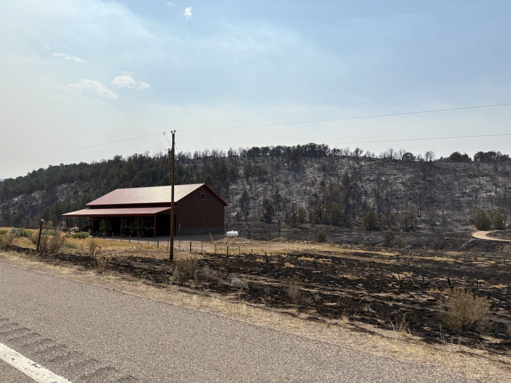
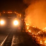
On Wednesday, firefighters along the Colorado Highway 13 corridor made progress despite challenging conditions. Cloud cover aided suppression efforts, and crews inside the fire reported decreased interior heat and smoke. On the southern edge, a spot fire just over County Road 5 held and did not cross into Garfield County. Lines from County Road 5 to County Road 3 remained secure. Additional crews focused on Highway 13 south to County Road 5 with the goal of reopening it when conditions allow. Four hotshot crews, engines and an unmanned aircraft system monitored for hotspots — work that will continue in the coming days.
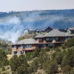
The Elk Fire remained within established control lines with minimal to no growth Wednesday. Crews continued to patrol and mop up, addressing creeping and smoldering hotspots and reinforcing lines around structures and other values at risk along County roads 8, 40 and 49. Favorable winds supported suppression efforts, keeping the perimeter secure throughout the day.
On Thursday, active fire behavior continued on the Lee Fire, particularly in the southern area. Crews planned to maintain point protection for communities, infrastructure and other values at risk. Direct line construction was set to continue on the east side of the fire and from Highway 13 south to County Road 5, as well as holding and improving lines between County roads 5 and 3. Hotspot detection will continue with unmanned aircraft flights, supported by hotshot crews and engines for rapid response. The hotspot near the Garfield County line will remain a priority for full suppression and reinforcement.
Elk Fire crews will continue patrolling and mopping up, reinforcing containment lines off County Road 8 and in the Beaver Creek area to keep the fire within existing lines while protecting nearby structures and other values at risk.
Evacuations and closures
On Wednesday, the Garfield County Sheriff’s Office upgraded the evacuation status of Zone 81 to “Go” (red), meaning residents should evacuate immediately. Zone 85 is in “Set” (yellow) status, indicating residents should prepare for a short-notice evacuation, while Zone 84 remains in “Ready” (green) status, meaning residents should monitor conditions and be prepared to leave.
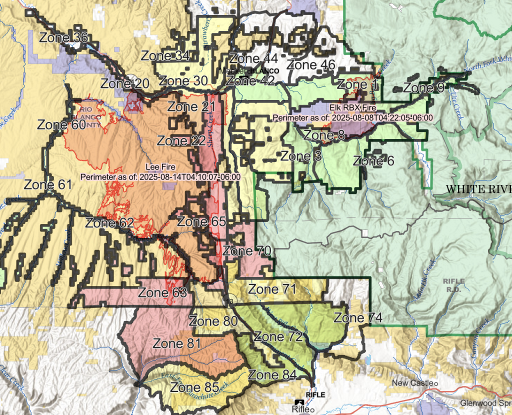
Zones 81 and 85 are located on top of the Roan Plateau in an industrial landscape and Bureau of Land Management area already under closure, not in residential neighborhoods. Other Garfield County evacuation statuses remain unchanged. Zone 70 is under “Go” status, while Zones 71, 80 and 85 are in “Set” status. Zones 72, 73 and 84 remain in “Ready” status.
In Rio Blanco County, “Go” orders remain in place for Zones 65, 64, 63 and 22 in connection with the Lee Fire. For the Elk Fire, evacuation statuses have been downgraded for Zones 1, 8 and 9, which are now in “Ready” (green) status.
Colorado Highway 13 and County Road 5 remain closed. Residents can check their evacuation status at bit.ly/lee-fire-zones. Sign up for Garfield County Emergency Alerts at garco911.com.


Support Local Journalism
Support Local Journalism
Readers around Glenwood Springs and Garfield County make the Post Independent’s work possible. Your financial contribution supports our efforts to deliver quality, locally relevant journalism.
Now more than ever, your support is critical to help us keep our community informed about the evolving coronavirus pandemic and the impact it is having locally. Every contribution, however large or small, will make a difference.
Each donation will be used exclusively for the development and creation of increased news coverage.