Lee Fire 6% contained; evacuations still in effect in Garfield County


John F. Russell/Steamboat Pilot & Today
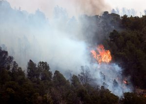
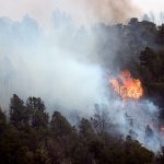
Update 7 p.m. Saturday: The Lee Fire, burning west of Meeker, has reached 6% containment and scorched over 92,000 acres, according to Watch Duty. The fire remained at 0% containment until approximately 6:30 p.m. Saturday.
The Elk Fire, located 11 miles southeast of Meeker, is burning on around 14,635 acres with 9% containment, according to Watch Duty.
Zone 70, located northwest of Rifle, remains at “GO” (Red) Evacuate NOW status. Officials upgraded the evacuation level around 2 p.m. Saturday due to the advancing Lee Fire.
Zones 71, 80 and 81 in northern Garfield County are still under “Set” (Yellow) evacuation status. Residents in these areas should be prepared to evacuate if needed. To check your evacuation zone, visit https://tinyurl.com/nxmx65hj.
The Parachute Rodeo Grounds, 100 La Plata Circle, Parachute, is available to house livestock in the event of an evacuation, according to the Garfield County Sheriff’s Office. Owners are urged to plan transportation, prepare leads and halters and bring water, medications and feed.
Highway 13 remains closed in both directions at mile marker 4, just north of Rifle, and from County Road 5 to Highway 64.
Original: Evacuation Zone 70, located northwest of Rifle, was elevated to “GO” (Red) Evacuate NOW status at about 2 p.m. Saturday due to the advancing Lee Fire, according to the Garfield County Sheriff’s Office.
Residents in Zone 70 should evacuate by heading south to Rifle on County Road 253 (Piceance Creek Road) to Highway 13. Highway 13 was closed in both directions at mile marker 4, just north of Rifle, around noon Saturday due to the fires, however, local traffic is still permitted through the closed area.
Zone 70 is the first evacuation zone in Garfield County to be placed under mandatory evacuation (Red status).
Around 6 a.m. Saturday Zones 80 and 81 in northern Garfield County were upgraded to “Set” (Yellow) evacuation status. Residents there are advised to remain alert and be prepared to leave if conditions worsen.
The Lee Fire, burning west of Meeker, is at about 92,047 acres with 0% containmnent. The southeast portion of the fire is becoming more active near County Road 60 and moving southwest from Highway 13. Air operations will continue to support strategic firing and firefighters are working to defend critical resources and private residences in the area, according to a 1:30 p.m. Saturday update from Elk and Lee Fire Information. An air quality alert due to smoke from the Lee Fire was issued for Garfield County on Saturday morning.
The Elk Fire, located 11 miles southeast of Meeker, is currently burning at around 14,635 acres with 8% containment.
This story will continue to be updated.


Support Local Journalism
Support Local Journalism
Readers around Glenwood Springs and Garfield County make the Post Independent’s work possible. Your financial contribution supports our efforts to deliver quality, locally relevant journalism.
Now more than ever, your support is critical to help us keep our community informed about the evolving coronavirus pandemic and the impact it is having locally. Every contribution, however large or small, will make a difference.
Each donation will be used exclusively for the development and creation of increased news coverage.