Glenwood Canyon time travel: A journey back through the history of travel through the ‘Grand River Cañon’ passage


Call them the James Deans of Glenwood Canyon.
Their “rebel” adventure — time trials on the old two-lane highway from Glenwood Springs to Hanging Lake and back.
Floyd Diemoz vividly remembers those carefree days of youth in the 1950s when he, Jim Rose and Glenn Vawter, among others, would sneak into the underground parking garage at the Rose auto dealership and swipe an Oldsmobile to take for a joy ride out into Glenwood Canyon.
“I remember a lot of trips through the canyon as a kid,” Diemoz recalls today. “It was a two-lane road; pretty dangerous in spots, but really neat.”
Before Interstate 70 was completed through Glenwood Canyon in 1992, the road through the canyon was simply known as U.S. Route 6 & 24.
Before that it was part of the Taylor State Road system, beginning as a wagon road in the early 20th century that was only passable during the summer months, according to historical accounts contained in John Haley’s 1994 book “Wooing a Harsh Mistress: Glenwood Canyon’s Highway Odyssey,” and later in Larry Rynearson’s 2017 compilation, “Legends of Glenwood Canyon.”

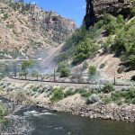
The Denver & Rio Grande Railroad was the first to make industrial-age passage through the deep, rugged canyon in the late 1800s.
During Diemoz’s youth, immediately east of Glenwood Springs U.S. 6 & 24 took a hairpin turn around Horseshoe Bend through No Name. This was before the twin No Name Tunnels that shortened that passage were built in 1965, signaling the start of the I-70 project through Glenwood Canyon.
“That was always something, and it could be pretty dangerous around that huge curve,” Diemoz said of the old stretch of highway that now serves as part of the Glenwood Canyon recreation path.
It was also the crucial, death-defying spot to navigate in those muscle car time trials.
They lived to not only tell about it, but help guide the future of what travel through Glenwood Canyon would become.
“That was Glenwood Canyon for us,” Diemoz said, also recalling many a fishing trip into the canyon, caving adventures or hikes up to Hanging Lake.
Rugged path
Diemoz expanded on that in Rynearson’s book, which is available for reference at the Glenwood Springs Library along with “Wooing a Harsh Mistress” and another popular reference, “A Guide to Glenwood Canyon” by Glenwood Springs author and former newspaper reporter/editor Heather McGregor.
“The need for a four-lane highway in Glenwood Canyon never occurred to those of us in the Class of 1955 at Garfield County High School in Glenwood Springs,” Diemoz writes. “The canyon was our playground as we explored caves or walked the antique rickety water trestle from the city’s water tanks to the granite tunnel from No Name Creek.
“We were even caught by a train in the western tunnel,” he recalled of another cheating-death moment.
A decade later, when chatter began about an interstate highway project, he would pen a letter to the editor of the Glenwood Post worrying about what would happen to the canyon if a traditional four-lane highway were blasted through it.
“Historically, when they built a highway by a river, they would plow the edge of the road into the river and blast away the hillside to make way for the road,” Diemoz explained in a phone interview last week.
The standard “cut-and-fill” method of highway building wouldn’t be acceptable in Glenwood Canyon if he and those who cared about the importance of that 12-mile run of the Colorado River had anything to do about it.
“We couldn’t let a highway take away the ability to have recreation in the canyon,” he said.
Diemoz became instrumental as a member of the state Highway Commission’s Citizens Advisory Committee in the ensuing debates about the best route for I-70 to take from the Eagle River Valley to Glenwood Springs, and ultimately how a four-lane highway through the canyon should be built, if that was the decision.
In 1971, Diemoz, a construction engineer by then, was joined by Rose and Glenwood residents Ed Mulhall and Jerry Brown in producing a film, complete with music and narration, that set the tone for the elevated highway structures that became the hallmark of the Glenwood Canyon design.
The film also took a virtual look at the Cottonwood Pass alternative that was given serious consideration at the time.
Diemoz explained that the Cottonwood route likely would not have followed the existing series of county and forest roads that still serve as a locals’ shortcut — including during the most-recent 15-day closure caused by the late July rock, mud and debris slides that ended with Saturday’s partial reopening of I-70 in the canyon.
There would likely have been tunnels and a massive bridge over the gulch on the Eagle County side where Cottonwood Pass Road meets Forest Road 8350, Diemoz said.
Beyond that, extensive private land acquisition would have been required on either side of the pass, he said.
The route around Glenwood Springs was never fully hashed out for the Cottonwood option, Diemoz said. But it likely would have jumped the Roaring Fork River somewhere near today’s Ironbridge Golf Course and Westbank residential subdivisions before skirting Red Mountain and the Wulfsohn Ranch along the old Midland Railroad corridor where Midland Avenue, several residential subdivisions and the Glenwood Meadows shopping center are today.
That film helped convince state and federal highway officials that the canyon, done right, was the best route.
However, the debate over cut-and-fill versus the more expensive cantilevered highway design and the resulting environmental challenges raged on for the better part of the 1970s before construction finally began to complete the “Final Link” of I-70 in Glenwood Canyon.
I-70 now runs uninterrupted from Baltimore on the east to its intersection with I-15 in Utah.

Early passage
Haley’s and Rynearson’s books both chronicle the early routes into and through what eventually became Defiance and later Glenwood Springs at the confluence of what would later be called the Grand (ultimately renamed the Colorado) and Roaring Fork rivers.
“Long before the white man came to Colorado, nomadic Native Americans had already established a network of foot paths, horse trails and easy access routes that adequately served their primitive needs,” Haley writes.
In the late 17th and early 18th centuries, “The Spaniards are credited with improving the trails when they entered the Colorado territory,” most likely to run a lucrative Indian slave trade, according to Haley’s account.
But their paths followed the least resistance, through the wider river valleys and over the high country across mountain passes and what’s now known as the Flat Tops.
The deep river canyons were too narrow to navigate and fraught with dangers, from falling rocks to churning whitewater.
By the frontier days of the late 19th century, travel into the Roaring Fork Valley was still preferred over what’s now Independence Pass into the silver boomtown of Ute City (later renamed Aspen).
If the destination was Defiance/Glenwood Springs, the best bet from points east was over the Flat Tops, through the original county seat of Carbonate and down what’s now Transfer Trail to the river valley.
“It was in 1887 that attorney Joseph Taylor, with his two grown nephews, Edward and Charles, came to Glenwood Springs,” Haley writes. “Edward became district attorney of the judicial district and referee over all water rights on the Roaring Fork, Grand and White rivers.
“Although he was best known as the ‘Father of Water Rights on the Western Slope,’ he also knew the value of roads.”
It was Edward Taylor’s vision to eventually build a wagon road through the “Grand River Cañon” east of Glenwood.
It finally came to be in 1899 when Taylor, then a state senator, sponsored the publicly financed Taylor State Wagon Road, ultimately connecting Denver and Grand Junction.
But it was actually the early railroad barons who first sought to blaze a path through Glenwood Canyon, though, with the first such line reaching Glenwood Springs in October 1887.
Three railroad companies initially had their sights on the canyon in the early 1880s, including the Burlington, the Union Pacific and the ultimate winner, the Denver & Rio Grande.
Railroad race
“In 1884, Jerome Wheeler, James Hagerman and some other Aspen silver barons used their wealth and influence over the Colorado Midland Railroad Company to begin building a standard-gauge track from Colorado Springs to Aspen,” Haley writes in his book of the beginnings of a race to lay the first tracks across the Continental Divide.
The standard-gauge line would traverse the mountains up through Leadville and over Hagerman Pass into the Fryingpan and Roaring Fork valleys to the silver mines of Aspen and the rich coal fields stretching from Defiance through the Grand River Valley.
“Not to be outdone, the Leadville silver barons and William S. Jackson, newly elected president of the D&RG, decided in early 1885 to beat the Colorado Midland to Aspen and the Grand River coal.”
Their narrow-gauge tracks would go north from Leadville down the Eagle River Valley and — gasp — through the Grand River Cañon to Defiance with spurs to Aspen and points west.
McGregor notes in her guide book that it was the western branch of the company led by Denver entrepreneur David Henry Moffat, the D&RG Western Railroad, that identified the route along the south bank of the Grand River through the canyon as the best bet.
Work was already well under way on the Midland line, but it was the D&RG-W that would ultimately come from behind to win that race.
That victory might be credited in large part to a team of workers called “the dynamite boys” of Glenwood Canyon, as told in Rynearson’s book.
In order to lay track through the canyon, four tunnels would need to be blasted through the granite walls to maintain a straight line on the south bank of the river.
The first tunnel is 280 feet long and situated 11 miles east of Glenwood Springs. The second is another mile down the track above Cottonwood Falls and is 133 feet long. Another “half-tunnel” is 185 feet, just below the falls. And the longest of the four is the Jackson Tunnel just east of town, at 1,331 feet long.
“Each day there were about 1,000 men working with picks, wagons, mules, shovels, horses, scrapers and dynamite,” Rynearson writes. “The ‘Dynamite Boys’ would pack black powder into hand-drilled holes, then fuse them and pack them with sand or clay. Three charges were ignited by gunpowder fuses, and the noise level increased!
“Chinese stone masons and laborers built support walls to widen and strengthen the railway,” Rynearson continues in his book. “They built the walls with carved rocks and were dry-laid and still support the weight of larger locomotives and heavier traffic without the benefit of mortar.”
It was on Oct. 5, 1887, that the first train passed through the Jackson Tunnel and arrived in Defiance. The D&RG was well on its way to beating out the Midland to the lucrative mines in Aspen.
Modern travel
Rynearson’s book is a compilation of entertaining stories and historical tidbits about Glenwood Canyon, from its geology, river habitat, vegetation, caves, travel and its importance to Glenwood’s water system.
McGregor’s “A Guide To …” serves as a point-to-point description of what all one can see and learn about in the canyon from west to east, including its flora and fauna, its relevance to Native American culture and its various points of interest, such as the Shoshone Dam and Power Plant. It concludes with short feature sections about the Jess Weaver, Grizzly Creek and Hanging Lake trails, Hanging Lake itself, the canyon’s geology and river habitat, and the railroad and highway history.
Haley’s “… Glenwood Canyon’s Highway Odyssey” dives deep into the history of travel through the canyon and how the interstate highway — with its massive bridge structures, four distinct roadside rest and recreation areas, recreation path, river put-ins and backcountry trailheads, including a protected Hanging Lake zone, and the high-tech Hanging Lake Tunnel command center — came to be.

“As the Taylor State Road took form in 1902, a determined W.W. Price drove the first automobile through Glenwood Canyon,” Haley writes.
Price had driven over from Colorado Springs, via Leadville and Tennessee Pass, and down the new road to Glenwood Springs.
“Here, he paraded his interesting nuisance up and down Grand Avenue, and according to local newspaper reports, ‘was endangering people’s lives by frightening their horses.’
“Glenwood Springs gave its first ‘gas buggy’ a frosty reception,” Haley concluded.
It was only a matter of time before there was no denying the wave of future travel, though.
During the Great Depression, then U.S. Rep. Taylor was able to tap into President Franklin D. Roosevelt’s New Deal stimulus, securing $36 million for a cross-state federal highway. State funds were also secured to improve U.S. 40 to the Utah line in the northern part of the state.
“Colorado employees of the Works Progress Administration and 30,000 young men in Civilian Conservation Corps camps found their labor in demand from border to border,” Haley writes.
The federal government earmarked $1.5 million in particular to widen and improve the Glenwood Canyon Road, creating 25 feet of paved surface with 2 feet of gravel shoulder on each side.
Dedication of the new road took place on June 9, 1938, and it officially became part of the transcontinental U.S. Highways 6 & 24 later that summer, on Aug. 1.
“Many turnouts appeared, with stopping, parking and picnic areas immediately adjacent to the road,” according to Haley’s account.
The Glenwood Canyon stretch of highway was dangerous, though, with several blind curves and routine accidents as vehicle speeds began to increase past 40 miles per hour and leisure activities in the canyon increased, he writes.
“The only real criticism of the 1930s construction projects came when traffic had to detour temporarily over Cottonwood Pass.”
Sound familiar?

Criss-crossing the country
Haley notes that it was the Federal Highway Act of 1944, authorizing a new 40,000-mile interstate highway system (later increased to 43,000 miles) that paved the way for I-70 through Colorado, ultimately including the Glenwood Canyon stretch.
But it nearly didn’t happen due to concerns about attempting to traverse the high passes and narrow canyons of the Rocky Mountains.
Colorado had requested an interstate route through the mountains four years earlier, but the path west of Denver took several more years to determine.
“For more than 20 years, Colorado tried and failed to obtain agreement with Utah for a highway connection at any border site,” Haley writes.
Complicating matters, the Bureau of Public Roads administrator at the time wrote in August 1946 that “neither U.S. 6 nor U.S. 50 (through Gunnison and Montrose) were acceptable because they involved mountainous terrain too costly to build.”
On Aug. 28, 1956, upon word that the deadline to qualify for federal funding was imminent, Colorado and Utah sent the bureau a request for approval. The bureau later agreed to add the 547 miles of I-70 from Denver to Cove Fort, Utah.
The first engineering effort in Glenwood Canyon came in the form of a cost estimate prepared during the spring 1960. The task of putting a price tag on the stretch of interstate from the Utah state line to Dillon was handed over to a young civil engineer named Dick Prosence.
A required local public hearing for the Glenwood Canyon section took place in Glenwood Springs in July 1963.
“There, people said they wanted to get rid of the notorious ‘Horseshoe Bend’ …,” Haley writes. “In response, the Department of Highways proposed eliminating the curve by boring twin tunnels through the ridge.”

Two years later, with little opposition, the tunnels were completed.
The same was certainly not true in the years to come, as the debate about completing that “Final Link” through the canyon was met by opposition from local residents and national environmentalists alike, including singer John Denver, who called Aspen home from the 1970s until his death in a plane crash on Oct. 12, 1997.
Denver would help fund and serve as the celebrity spokesman for the Aspen-based Citizens for a Glenwood Canyon Scenic Corridor. The group lobbied for the Cottonwood route to be selected instead. Among their concerns was the potential environmental damage that could be caused in Glenwood Canyon if an interstate highway were placed there.
Despite the concerns and legal challenges that ensued, with the promise of an environmentally friendly highway design, the canyon route was formally selected in 1976.
The result was what’s been referred to as an “engineering marvel” that now exists in the canyon, employing European highway-building techniques to construct a highway over instead of blasting into the fragile canyon walls, while protecting the river below and preserving the many recreational amenities the canyon has to offer.

Prosence, who died last year, reflected back in an interview with the Glenwood Post as the Glenwood Canyon Project neared completion in October 1992, saying “Glenwood Canyon was not the first project where the environment had a strong position in how it was to be designed and constructed.”
The canyon project “is in many eyes the evolution of those original concepts into what’s now regarded as, not only an engineering marvel, but one that’s in tune with its natural environment,” Prosence said in that interview, a portion of which is included in Haley’s book.
“There’s not another section of highway in the country that you can compare it to in terms of its spectacular nature.”
Senior Reporter/Managing Editor John Stroud can be reached at 970-384-9160 or jstroud@postindependent.com.


Support Local Journalism
Support Local Journalism
Readers around Glenwood Springs and Garfield County make the Post Independent’s work possible. Your financial contribution supports our efforts to deliver quality, locally relevant journalism.
Now more than ever, your support is critical to help us keep our community informed about the evolving coronavirus pandemic and the impact it is having locally. Every contribution, however large or small, will make a difference.
Each donation will be used exclusively for the development and creation of increased news coverage.