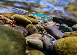
Roaring Fork watershed’s low snowpack runoff will change fishing, rafting this summer


Austin Colbert/The Aspen Times
Matthew Anderson didn’t mince words about the snow from this past winter.
“The winter was quite bad,” said the water quality technician with Roaring Fork Conservancy in Basalt. “Record-breakingly bad.”
Throughout Colorado this past winter season, ski areas experienced low snow totals; many of them closed earlier than projected. Bookings were down. Snowpack was measurably depleted.
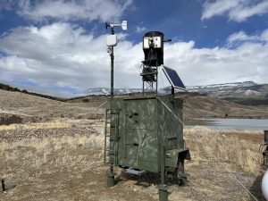
Peak snowpack, Anderson said, is one of the touchstones the nonprofit examines most closely — both the amount of snow and the timing of it. Data from nine SNOTEL sites in the higher elevation areas of the Roaring Fork watershed is collected and then averaged.
“This year,” he explained, “peak SWE was 9.3 inches, and that occurred on March 10. When we look back, the median peak SWE — meaning just the average — is typically on April 7 at 17.1 inches.”
SWE measures the actual water content in the snowpack; it also contains air and other things mixed in.
“When you look at those numbers,” Anderson explained, “our peak SWE was about a month early and about half of normal. It’s a big deal.”
Every day since Jan. 27, he added, looking at the entire record, a new minimum in SNOTEL data has been set.
“First and foremost, when we have less snow, we’re going to have less water in rivers and streams. That makes sense to most people,” he said. “Typically, snowpack builds and builds, it peaks and then the temperatures start to warm, and that’s when we start to see it melt off. When that is happening, runoff is building in rivers and streams — that’s sort of the normal pattern.”
Based on historical data, peak snowpack usually arrives in early April, he said. From then, it starts to melt, and water flows start to rise. Peak runoff is typically around the first week of June.
“But maybe the part that is a little harder to wrap your head around is just how early all of this has happened,” he added. “The fear for this year is that we are so far ahead of schedule. The last weeks in March were not just record-breakingly warm but far and above record-breakingly warm.”
The higher-than-average temperatures during that heat spell — 15-20 degrees higher, based on historical weather data — “tanked” the lower elevation snowpack, that which rests at 8-9,000 feet, Anderson said.
“In our SNOTEL sites — that’s McClure Pass, Crystal headwaters, Nast Lake, in the Fryingpan headwaters — sites like those ran out,” he said. “They were out of measurable snowpack, well ahead of schedule. So we lost that first chunk.”
April cooled the area down, he added, and that slowed down the snowmelt.
“But we already lost such a big chunk that we’re not expecting flows to rebound toward what’s more normal,” he said.
Comparing peak runoff flows

While staff at the Roaring Fork Conservancy observed this past winter playing out poorly, they thought to sift through records of other poor, low-snowpack years, specifically in the Roaring Fork watershed.
“2012 was, at the time, the lowest snowpack year,” Anderson said.
2012 also had the lowest peak runoff of the Roaring Fork, measured off the U.S. Geological Survey gauge at Vestus Park in Glenwood Springs, he said. That occurred on June 2 that year, with the peak runoff flow at 2,110 cfs.
“We also looked at 2002, 2018 — both poor years,” he said. “1977 was a really poor year — that actually predates the SNOTEL sites, so the snowpack data isn’t exactly comparable.”
However, the peak runoff flow for 1977 is known, he added; this was measured then at just under 2,500cfs.
“So in that 2-3,000 range, those are some of our poorer runoff years,” he said. “An average peak runoff on the Roaring Fork in Glenwood Springs would be around 7,000 cfs.”
To put those poor years in perspective, Anderson said, on March 27 of this year, the highest flow recorded on the USGS gauge at Vestus Park in was 878 cfs.
“It remains to be seen if there will be enough upcoming snowmelt to surpass this,” he added.
Currently, the remaining snowpack is mostly above 10,500 feet because the four of nine SNOTEL sites that have notable snowpack are all above that elevation, he said.
“That being said,” he said, “those sites are all well below average for this time of year, so it is possible we may not get much more snowmelt. If that were the case, the March 27 flow of 878 cfs would be the peak runoff, which would be well below the historic minimum and well earlier than the historic minimum.”
Like any year, he added, there is potential for days-long rain storms and monsoonal patterns to have a longer effect on flows; rain events boost flows, but it’s temporary. That’s why snowpack is so important, he said, as its gradual melting, in a normal year, gives those sustained flows throughout the water year.
“We certainly need it — we’re very happy to see the rain when it comes,” Anderson said. “But we know that it is not going to change the game in a huge way.”
There are several factors contributing to the poor runoff, but low overall snowpack and record-breaking high temperatures in March are key drivers, he said.
How will this year affect flyfishing and rafting?
With lower flows due to the poor snowpack this year, the water temperatures will rise that much faster, and that can cause some serious problems for the fish in the watershed. But upvalley locations might offer some respite.
“The silver lining is if people just head upvalley — the higher you go, the colder the water gets if we end up dealing with any warm water problems,” said. Scott Spooner, manager at Taylor Creek Fly Shop in Basalt.
The Fryingpan River — both above and below Ruedi Reservoir — the Crystal River, areas around Independence Pass, various high country creeks and lakes throughout the watershed that can be hiked to, all of these, Spooner said, are very embraceable options on hot days.
“There are probably 100 little creeks in this valley if you add them all up,” he said.
The Roaring Fork River from Carbondale to Glenwood Springs and the Crystal River a bit upstream from Carbondale to the Roaring Fork are where Anderson, other Roaring Fork Conservancy staff and area fishing guides have measured high water temperatures in the summer months.
These areas are voluntary fishing closure locations initiated by Colorado Parks and Wildlife, he added.
One of the conservancy’s programs, Hot Spots for Trout, is a collection of volunteers who go out with provided thermometers and measure temperatures all over the valley, inputting the data into a shared document.
“68F is our threshold,” Anderson said, “where we’ll say, ‘Reel it in, and find another location’ or ‘Come back earlier on another day when the water temperatures are a little cooler.'”
The Roaring Fork Fishing Guide Alliance works with Colorado Parks and Wildlife to set up signage at critical river access points indicating increasing water temperatures on hot days.
“We work to get the word out to our membership and the guide and angling community: ‘The water is low, it’s hot, it’s getting to a critical temperature at this time of day — let’s try to get our fishing done before these temps hit,'” said Kyle Holt, president of Roaring Fork Fishing Guide Alliance.
Holt added, “We have probably already seen the peak of our runoff, which is really unbelievable for all of us when we think about it. Our biggest concern is the health and well-being of the fish, environment and rivers.”
Protecting the fish is a common thread that binds area fishing guides together.
“If we put stress on our resources, specifically the fish, they’re not going to live,” said Taylor Thackston, owner of Frying Pan Angers in Basalt. “If we’re fishing for them in hot water, if we’re fighting them in hot water, if we’re taking pictures of them out of the hot water, they’re not going to survive.”
Thackston emphasized the commitment to not putting extra stress on fish.
“We’re conservationists first,” he said.
From a guide standpoint, Holt said, there may be a customer who has been floating down the lower Roaring Fork and Colorado rivers for the last 30 years and wants to go down there fishing during the hot, summer months.
“You’re going to have to explain what’s happening,” he said. “Ninety-nine percent of fishers are 100% okay with it.”
Jim Ingram, who owns Aspen Whitewater Rafting and started as a rafting guide in 1995, said that the rafting industry has changed with the water over the decades he’s been in the business.
“The rafting industry, we’ve adapted to lower flows — and we’ve always done that,” Ingram said. “We used to use these big, monster 16-foot boats, and there was plenty of water to float on. Now we’re running on 10 and 12-foot boats and only holding six people or four people.”
Inflatable kayaks and smaller rafts have been added as options, too, he said.
The change has been ongoing, he added, because there is just not as much water in the West as there used to be years ago.
“The reasons why people come here is because we offer such a diverse amount of offerings,” he said. “You can go party your brains out at night, you can go to concerts, you can go listen to classical music, you can go hike the Bells, you can go to the Grottos, you can float the river, you can fish the river. If we continuously say ‘Oh, don’t do this and don’t do that because it’s not perfect,’ then we’re missing the point.”
Spooner has been taking in stride the low snowpack and how the year will shape out with the water, but he remains cautiously optimistic.
“The crystal ball is a little tough this far out,” he said. “If we get a nice cool spring and lots of wetness, we might just be okay.”
Original reporting from aspentimes.com
Roaring Fork watershed’s low snowpack runoff will change fishing, rafting this summer
Throughout Colorado this past winter season, ski areas experienced low snow totals; many of them closed earlier than projected. Bookings were down. Snowpack was measurably depleted.


Support Local Journalism
Support Local Journalism
Readers around Glenwood Springs and Garfield County make the Post Independent’s work possible. Your financial contribution supports our efforts to deliver quality, locally relevant journalism.
Now more than ever, your support is critical to help us keep our community informed about the evolving coronavirus pandemic and the impact it is having locally. Every contribution, however large or small, will make a difference.
Each donation will be used exclusively for the development and creation of increased news coverage.